A summer of sun and storms; reduced risk for extreme heat, drought & wildfires

The Weather Network's official 2022 Summer Forecast reveals what Canada can expect for the heart of the summer season.
--
The most anticipated season of the year is finally here!
After a sluggish spring that tested our patience, will we be rewarded with an ideal summer for enjoying our favourite outdoor activities? For an overview of what we expect across Canada during the remainder of June, July, and August, please read on.
We expect the upcoming summer to feature widespread warm weather as most of Canada will see near-normal or above-normal temperatures.
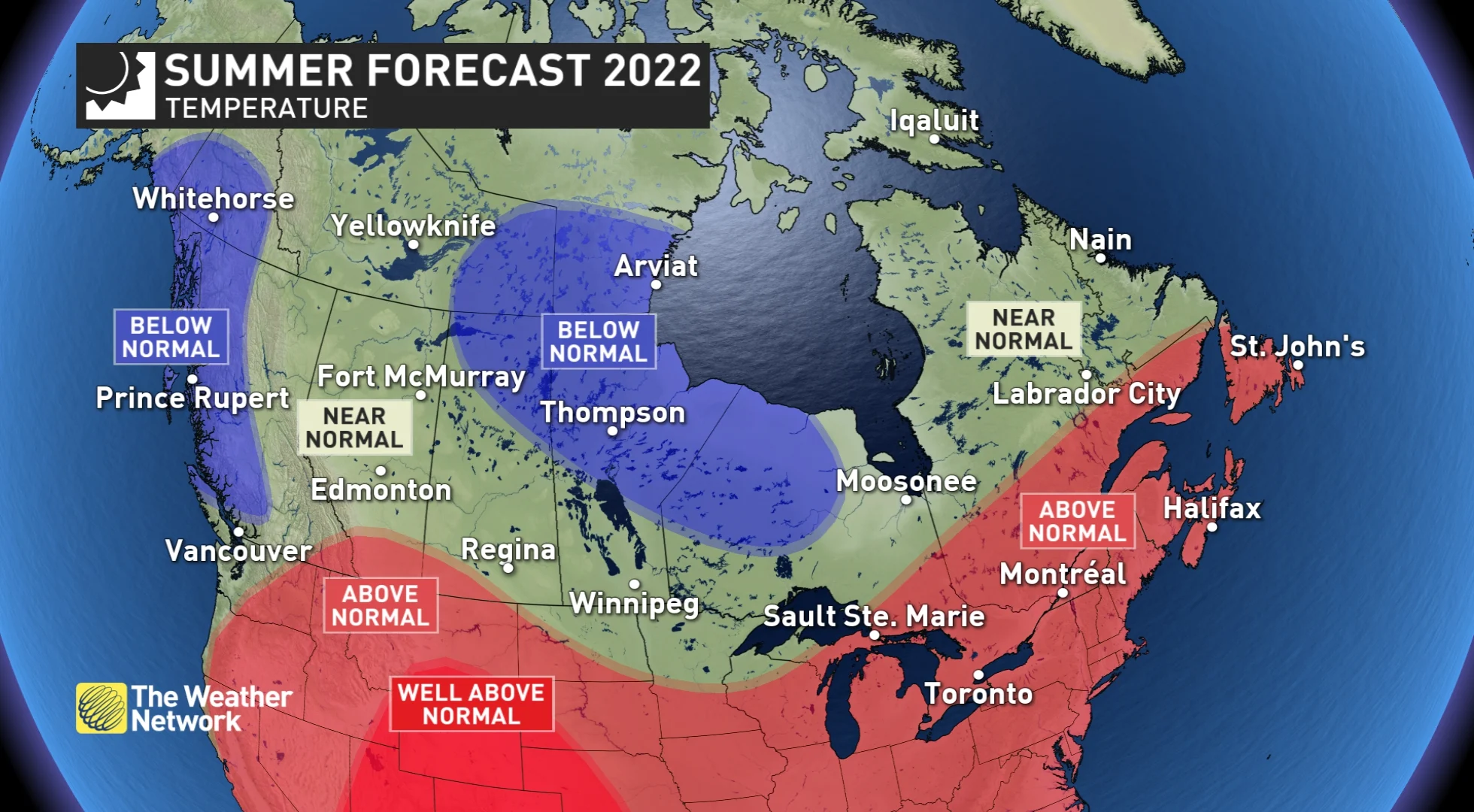
The temperature pattern expected across Canada this summer. (The Weather Network)
Despite the widespread “above normal” temperatures featured on the map above, for western Canada this summer will not feature widespread extreme heat like what we saw last summer. However, we are expecting heat and humidity combined with an active jet stream pattern to contribute to a rather stormy summer at times across much of the country.
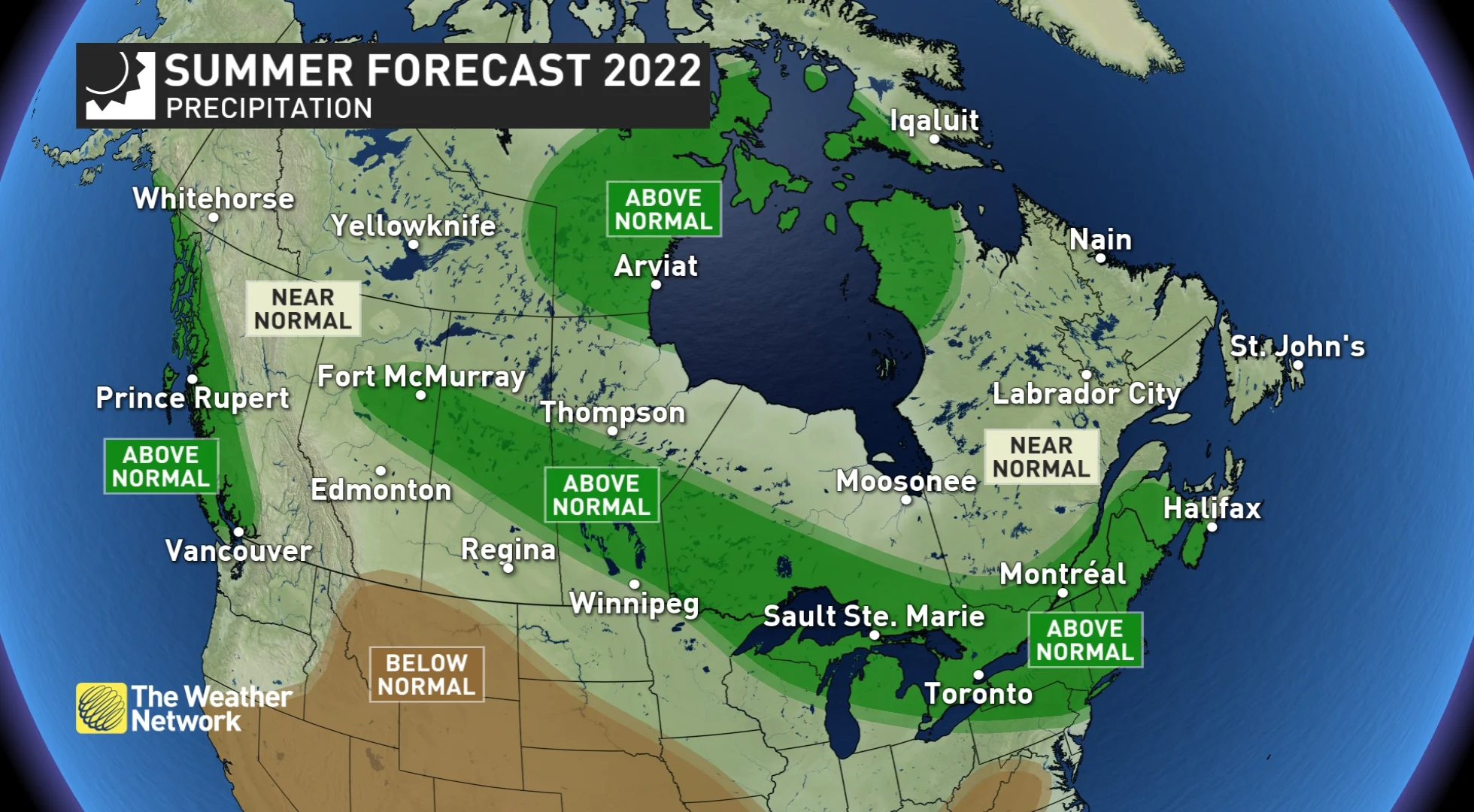
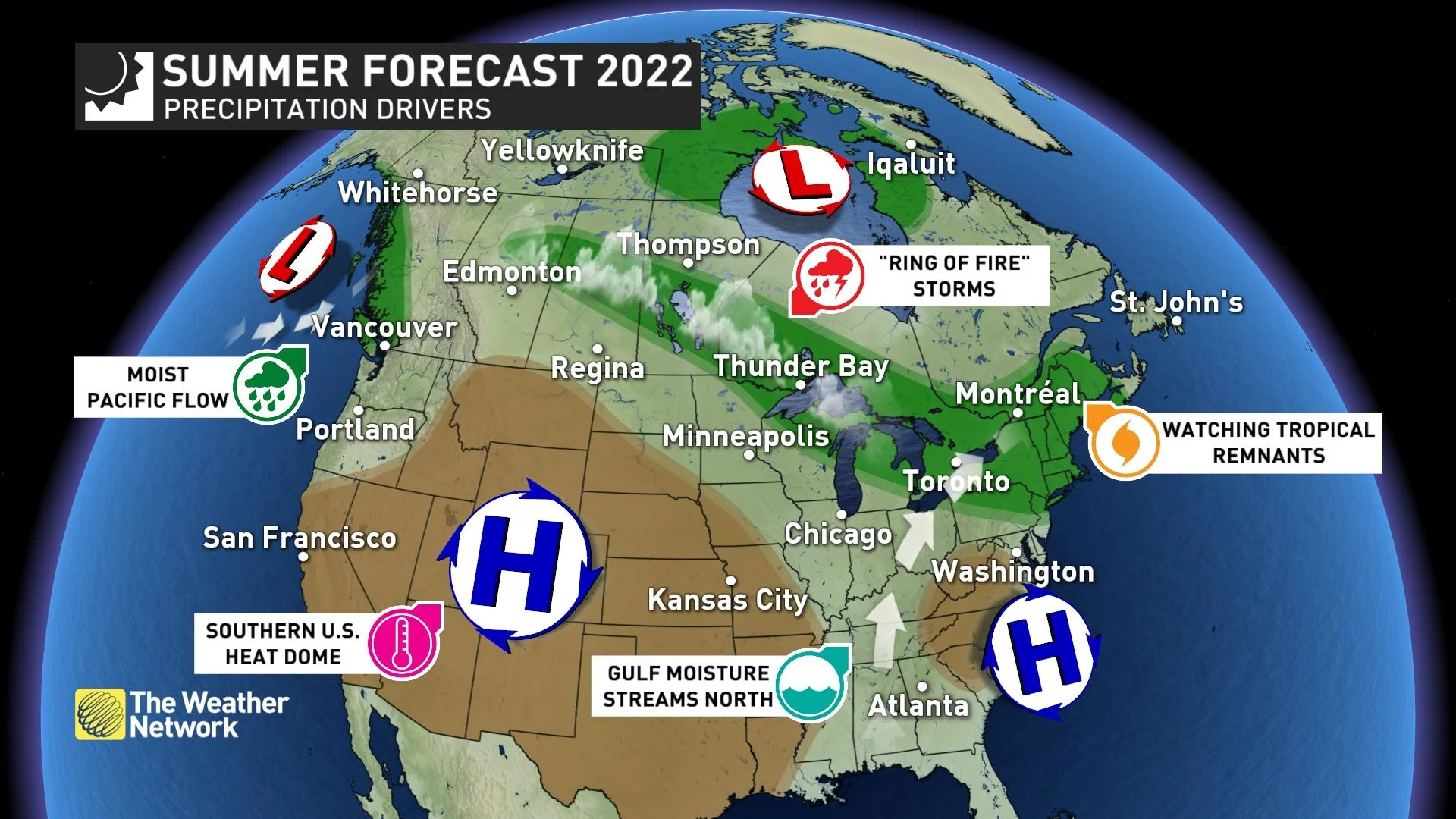
Above is a look at our precipitation forecast for the next three months. (The Weather Network)
While thunderstorms will interrupt our plans from time to time, they will also usher in periods of cooler weather to provide relief from the heat.
DON'T MISS: The heat is on. Here are 6 things you'll need to keep cool
Parts of Canada will still experience drought and wildfires, as they are a part of every Canadian summer—however, it appears that widespread drought, wildfires and smoke are much less of a concern this summer compared with many recent years.
Below is a more detailed look at the regional conditions expected this summer:
BRITISH COLUMBIA
The cool and unsettled pattern that dominated during spring has continued through much of June thus far. As a result, the alpine snow is currently much deeper-than-normal.
A benefit of this pattern is that we will see a later start to the wildfire season, as well as a shorter season. While wildfire are an inevitable part of every summer, we do not expect wildfires and smoke will be anywhere near as big of an issue this year as they were last year and during many recent summers.
As we head into the heart of summer, we expect temperatures and precipitation amounts will trend back to near-normal, with periods of hot and dry weather at times. However, much of the coastal region will be cooler than normal for the season as a whole.
WATCH BELOW: WILL THE 'HEAT DOME' RETURN TO B.C. THIS SUMMER?
READ MORE: Heat is on the horizon. Here are 6 things you'll need to keep cool
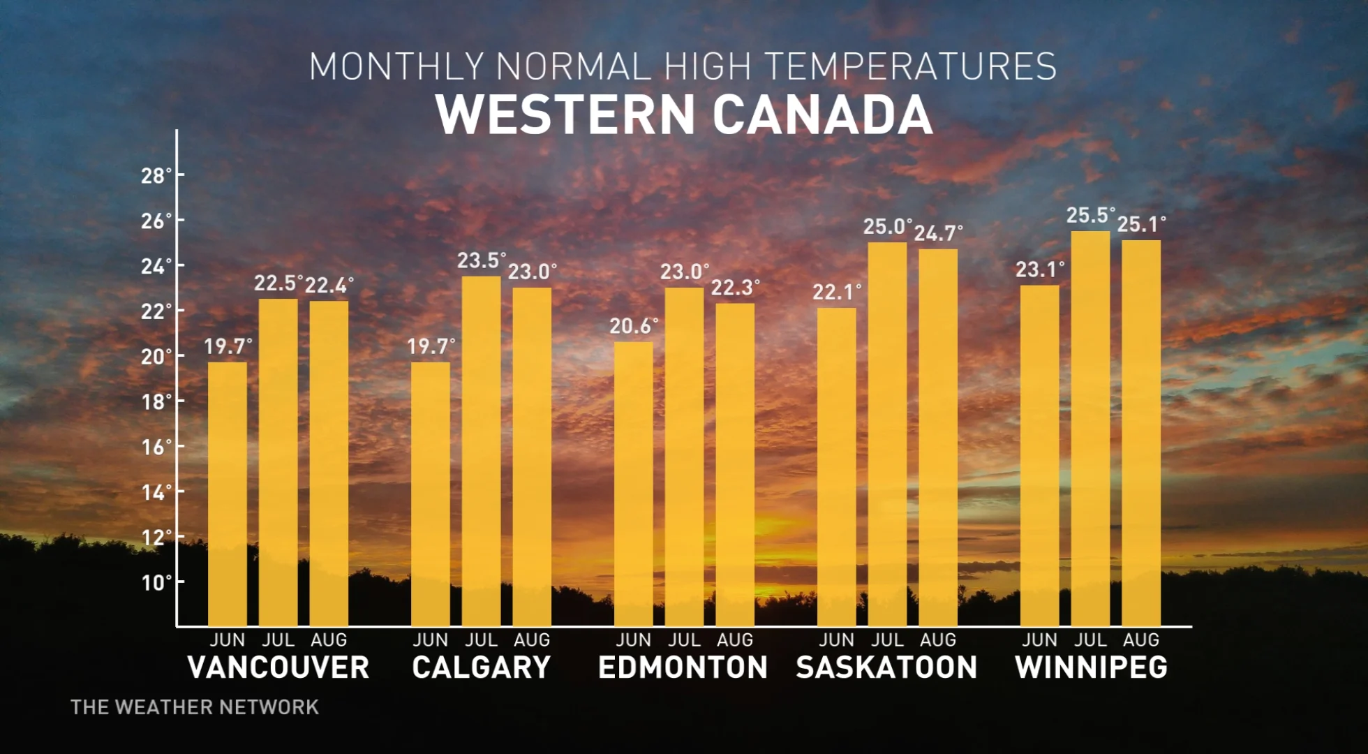
ALBERTA
The summer of 2022 will not be as hot as what we endured last summer. However, there will still be periods of hot weather, especially across southern parts of the province.
Throughout the heart of summer, there will also be periods of cooler weather that will provide relief from the heat at times. This is why we're forecasting near-normal temperatures overall for summer across central and northern parts of the province, including Edmonton and Fort McMurray. Meanwhile, southern parts of the province—including Calgary—are expected to tip warmer-than-normal.
The biggest concern as we started the month of June was the ongoing drought across southern parts of the province. However, the past few weeks have featured a dramatic pattern reversal with widespread heavy rain and thunderstorms. Parts of southern and central Alberta could see June 2022 end up among the Top 5 wettest Junes on record.
As we head into July and August we expect that we will settle into a more typical summer pattern with a risk that parts of southern Alberta will turn very dry once again. However, a more stormy pattern is expected further to the north, with localized excessive rainfall possible at times.
WATCH BELOW: HOW THE U.S. DROUGHT CAN IMPACT SUMMER ACROSS THE PRAIRIES
SASKATCHEWAN AND MANITOBA
A much cooler summer is expected across the region compared to last summer. There will be heat waves, but the heat will be interrupted by periods of cooler weather. The back-and-forth swings in temperature should come close to offsetting each other for most of the region including Winnipeg, Regina and Saskatoon. However, southwestern parts of Saskatchewan, including Swift Current, are expected to tip to the warm side of seasonal, while northern parts of the region are expected to tip to the cool side of normal.
The biggest concern as we approached the start of June was the excessive rainfall which had plagued southern Manitoba and southeastern Saskatchewan. Spring planting was completed much later than normal across this region. An active storm track across parts of the region is expected to be a concern at times through the summer, but overall we are cautiously optimistic that heart of summer will be more favourable for agriculture.
ONTARIO
A very warm and humid summer is anticipated across much of the province, with the exception of the northwestern region.
A few heat waves are likely to occur, especially across southern and eastern parts of the province, including London, Toronto and Ottawa, with periods of cooler weather providing relief from the heat at times. Due to the heat and humidity and several cold fronts tracking across the region, we expect stormy weather at times.
These storms will produce a wide range in rainfall totals, with some areas seeing above-normal precipitation, while nearby places could frequently miss out and turn quite dry at times. We have already seen this pattern during the first three of June with parts of southern Ontario turning rather dry despite frequent storms in the area. Overall, though, we expect a favourable season for agriculture and numerous sunny days for enjoying outdoor activities.
WATCH BELOW: THE 'RING OF FIRE' TAKES AIM, WHAT THIS MEANS FOR SUMMER IN ONTARIO
SEE ALSO: If you're hot, they're hot. 6 things to help cool down your pet
QUEBEC
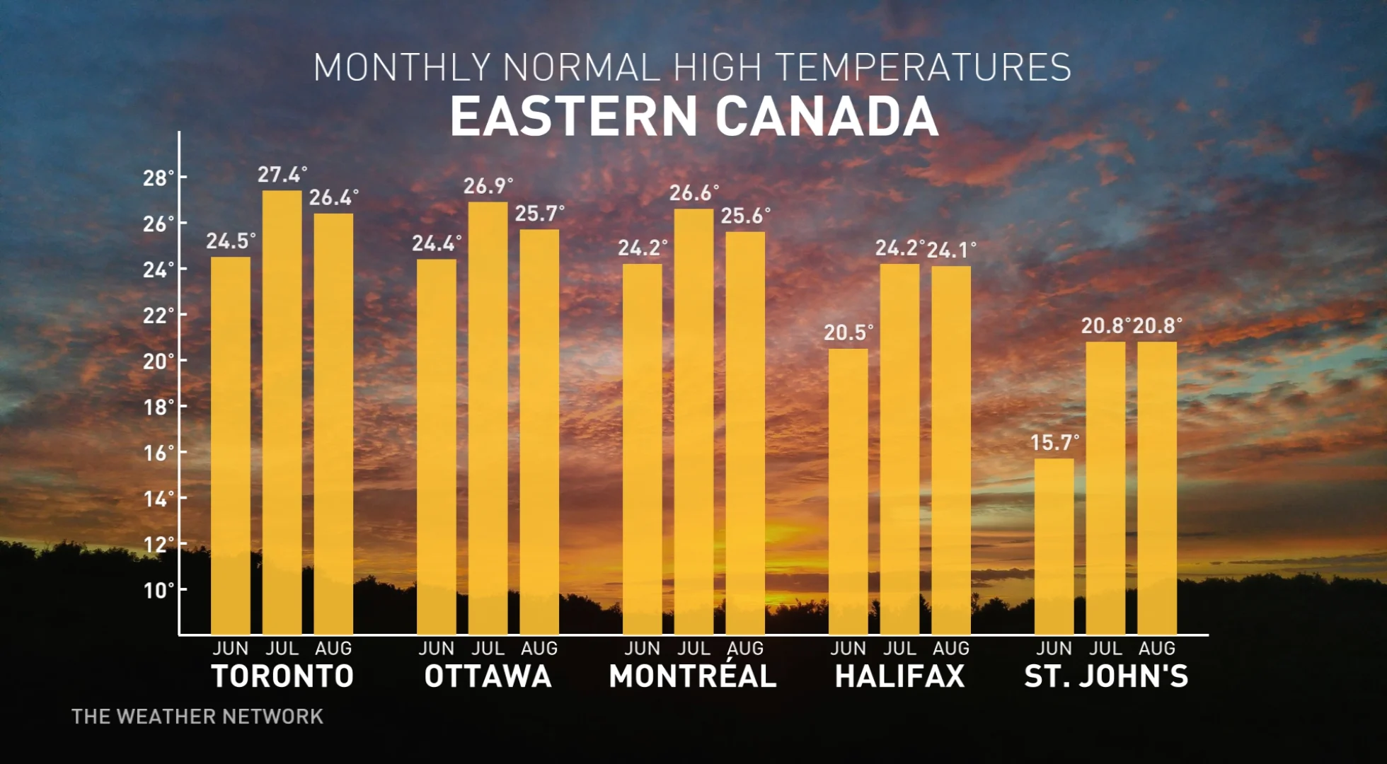
A very warm and humid summer is expected across southern and eastern parts of the province, including Montreal and Quebec City. A few heat waves are likely across this region, but periods of cooler weather will provide relief from the heat at times.
Due to the heat and humidity and several cold fronts tracking across the region, we expect stormy weather at times. These storms will produce a wide range of rainfall totals with many areas seeing above-normal precipitation. However, some places could frequently miss out and turn rather dry at times.
Overall, we expect a favourable season for agriculture and numerous sunny days for enjoying outdoor activities.
WATCH BELOW: HEAT AND HUMIDITY COULD FUEL FREQUENT ROUNDS OF THUNDERSTORMS
THE MARITIMES
A very warm and humid summer is expected overall, but occasional cold fronts will bring stormy weather and provide some breaks from the muggy conditions.
Near or above-normal precipitation is forecast across the region, but we expect that a few moisture-laden systems will account for a large percentage of the rainfall totals for the season. This will still allow for extended periods of dry weather for enjoying outdoor activities.
Meanwhile, we will keep a very close eye on the tropics throughout summer and into fall. A very active season is expected, with a heightened risk for tropical systems to impact the region (scroll down below for a more in-depth look at the upcoming hurricane season).
WATCH BELOW: LA NIÑA WILL PLAY A KEY ROLE THIS SEASON ACROSS EASTERN CANADA
NEWFOUNDLAND AND LABRADOR
A very warm and humid summer is expected across Newfoundland. Periods of cooler weather are likely, as well, but temperatures should tip to the warmer side of seasonal. Meanwhile, across Labrador, the back-and-forth temperature swings should come close to offsetting each other.
Near-normal rainfall totals are forecast across the region, but we will keep a very close eye on the tropics, where a very active hurricane season is anticipated. If the remnants of a tropical system tracks across the province, then we could readily end up with above normal rainfall totals.
NORTHERN CANADA
Near or cooler-than-normal temperatures are expected across most of the region with the coolest weather relative to normal across southern Nunavut and southern Yukon. Meanwhile, near to above-normal precipitation is expected across the region, with the wettest weather expected around northern parts of Hudson Bay. As a result, we can expect a reduced risk for wildfires and smoke across this region.
WATCH BELOW: REDUCED RISK FOR WILDFIRES AND SMOKE ACROSS THE NORTH
HURRICANE SEASON
All signs point towards another very active tropical season, and it looks like the season will get off to an early start.
While it is much too early to have confidence in storm tracks, the global pattern appears to favour a slight eastward shift in the dominant storm track which should result in fewer storms in the western Gulf of Mexico than we have seen in recent years, but more storms tracking near the U.S. east coast. That track would also mean a slightly higher risk for eastern Canada to be impacted by the remnants of a tropical storm or hurricane.
Warmer-than-normal sea surface temperatures near the east coast of Canada and the United States also heightens the risk for storms to strengthen or maintain their intensity as they approach the coastline. For a more detailed look at the hurricane outlook, watch the video below.